You can feel the steady increase of elevation on the drive up to John Boyd Thacher State Park. At the entrance, you are rewarded with a view from the top of the world—or at least New York.
It’s like looking at a scenic landscape puzzle of the Hudson and Mohawk River valleys. Nothing seems real. Somewhere below is the Indian Ladder Trail, an old Native American shortcut from the top of these steep cliffs to a limestone-lined path 60 feet below. The path was used by the Schoharie Indians as a trading route, so they built actual ladders to scale the cliffs.
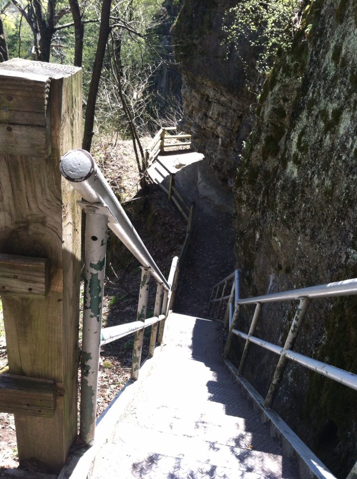
 In the 1700s, travelers from the western hills of the Schoharie Valley to the Hudson River Valley cut tall trees and leaned them against these cliffs. They trimmed back the branches and used them to climb. Early settlers called these trees Indian ladders. But these days, you won’t have to scale a 60-foot Indian Ladder, just a modern metal staircase.
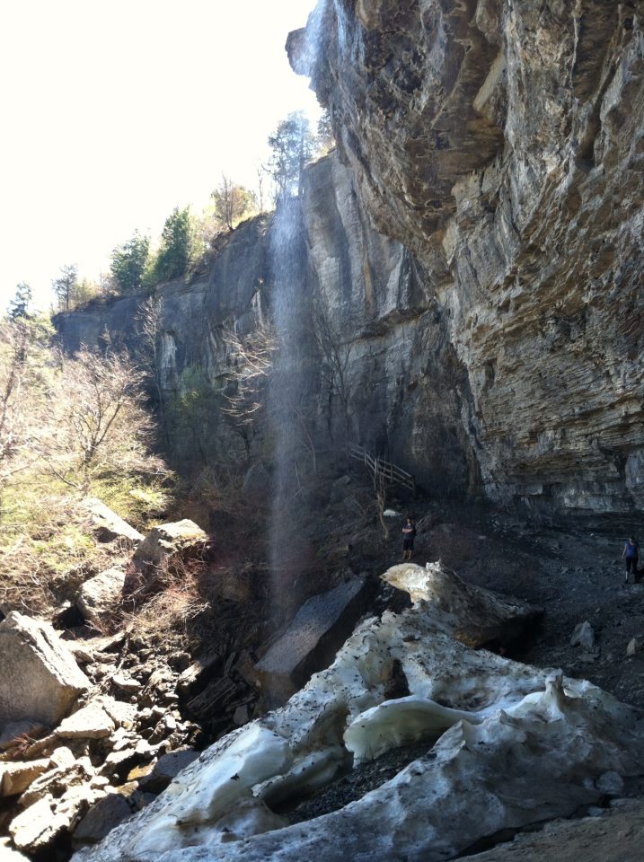
“Let me show you something,” says a woman behind the front desk of the information center. We go into a separate office and she points to a picture of a frozen waterfall. “This is why we can’t open the trail till May.”
 The picture is of a still and silent Minelot Falls, along the half-mile trail. During the winter, the waterfall freezes, creating a column of ice from top to bottom. It takes until May for it to melt down to a safe enough level for hikers to walk under.
Today is opening day.
It’s an easy descent down the metal staircase and soon I am surrounded by a forest, caves and a rocky landscape full of history.
 The limestone cliffs are the only remnants of the ancient sea that covered a good portion of New York State hundreds of millions of years ago.
Fossils of the shells of sea animals can still be seen today in the limestone walls. Eventually the sea drained away and the landscape changed. Streams eroded the limestone layers, leaving behind a Tetris-like, almost pixelated surface lining one side of the dirt trail, a 700-foot deep valley filled with trees on the other.
On one corner, you actually have to crawl under jutting limestone and just around the bend narrow passageways, more like giant cracks, that lead to dark caves within the limestone.
During the American Revolution a British loyalist, or Tory, hid in one of these caves and led raids on patriot farms in the valley below. The smoke from his campfire streaming through cracks in the limestone gave his hiding spot away and he was soon captured in what later was named the Tory Cave.
A little farther is the cascading Minelot Falls. And even today on an 86-degree day, there are chunks of snow and ice at its bottom. A bridge crosses an underground stream flowing from the base of the cliffs.
The entire trail, there and back, is only one mile so for those of us who aren’t exactly outdoorsy hikers, this is an easy foray into another world that shouldn’t take you more than an hour to complete. But as all things that go down have to come up, you will have to climb back up another metal staircase at the end of the trail.
From Long Island it’s about a 3.5-hour trip to Voorheesville, just outside of Albany. Today there are only about 15 people scattered throughout the trail. Along the way there’s a group of college-age guys posing in front Minelot’s chunk of ice.
They’re wearing Commack High School T-shirts.