
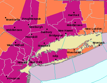
Long Island is under an excessive heat warning as Friday made for the hottest of the heat wave that tied the region’s record for duration—six days—and may break that record.
The excessive heat warning in effect from 11 a.m. to 8 p.m. Friday was prompted by heat index values that make temperatures in the 90s feel like more than 105, according to Upton-based National Weather Service meteorologists.
The warning covered much of the tri-state area, Nassau County and the western half of Suffolk. The East End is under a heat advisory.
All of LI is also under an air quality advisory, which occurs when excess heat causes increased airborne pollution levels that can make breathing difficult.
Officials have repeatedly warned the public to stay hydrated, stay in air conditioning and don’t perform strenuous activities outside during the peak afternoon hours.
The Nassau and Suffolk SPCA are also urging pet owners to keep their animal companions cool, preferably indoors and not leave them in hot vehicles.
If temps break 90 as forecast Saturday, the heat wave will hit seven days, breaking the 1993 record set in Islip, where records only go back to 1984.
But, a cold front moving in this weekend should cool the Island down with a chance of rain Saturday into Sunday, giving way to a week with temps in the 80s.