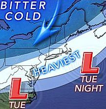
The forecast for the arctic-blast-accompanied winter storm heading toward Long Island on Tuesday has worsened, with eight-to-10 inches of snow now expected and up to 14 inches on the East End.
The winter storm watch has been upgraded to a winter storm warning between noon Tuesday and 6 a.m. Wednesday, meaning severe winter weather conditions are expected, according to Upton-based National Weather Service meteorologists.
“Significant amounts of snow are forecast that will make travel dangerous,” the agency said in a statement. “Only travel in an emergency. If you must travel, keep an extra flashlight, food and water in your vehicle in case of an emergency.”
The flakes are forecast to start falling Tuesday afternoon, with the heaviest accumulations expected during the evening—making the Tuesday night rush-hour commute a mess—before tapering off overnight into Wednesday morning.
Temperatures are expected to hover around 20 with wind gusts of up to 35 mph, making it feel below zero when the temps drop into the teens after sundown.
Visibility of a ¼ mile or less are possible at times, although the weather service stopped short of terming the storm a blizzard.
Forecast warned of the possibility of frost bite for those not dressed appropriately. The return of the arctic air mass known as the polar vortex is expected to follow the storm and likely bring with it subzero wind chills Tuesday into Wednesday, forecasters said.
Temps will stay in the 20s after the storm passes Thursday and Friday and hover in the 30s through next weekend, when the forecast calls for mostly sunny skies.
A meteorologist said Nichols Road, connecting Port Jefferson on the North Shore and Patchogue to the south, is the expected line between the lesser amounts to the west and the more than a foot of snow forecast for the Twin Forks.