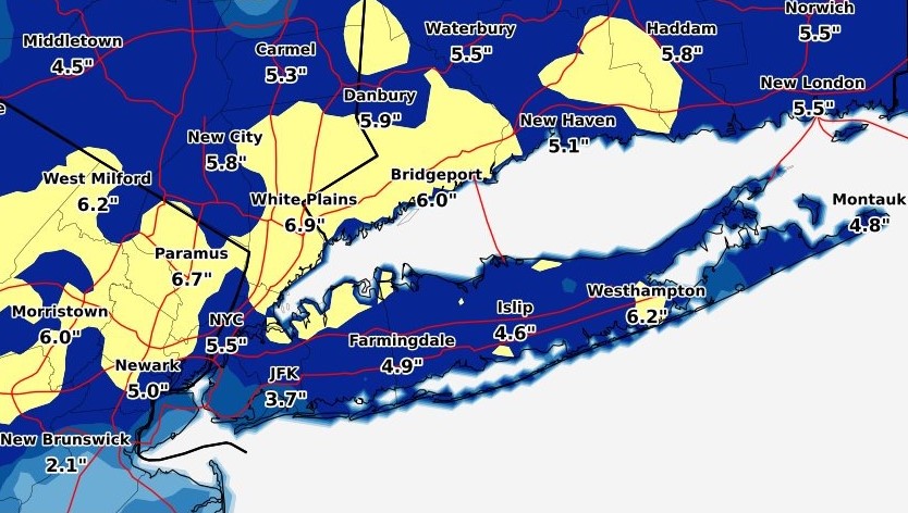
A snow storm dumped seven inches of the white stuff on parts of Long Island on Monday morning, nearly twice the average amount forecasters predicted.
The National Weather Service (NWS) reported the highest amount in Nassau County was 7 inches in Centre Island and the highest accumulation in Suffolk was 6.6 inches in Sayville.
Here is the full list of reports:
Nassau County
Centre Island 7.0 1100 AM 4/02 Law Enforcement
Manhasset 6.3 1035 AM 4/02 Trained Spotter
Oyster Bay 6.3 1012 AM 4/02 Fire Dept/Rescue
East Hills 6.0 1030 AM 4/02 Public
Massapequa 5.6 1030 AM 4/02 CoCoRaHS
East Williston 5.5 1015 AM 4/02 Public
Plainview 5.0 1030 AM 4/02 Trained Spotter
Albertson 5.0 1030 AM 4/02 CoCoRaHS
1 S Merrick 4.8 1044 AM 4/02 Trained Spotter
Bethpage 4.8 1000 AM 4/02 Public
Old Bethpage 4.5 1200 PM 4/02 Trained Spotter
East Meadow 4.5 925 AM 4/02 Social Media
Wantagh 3.9 1005 AM 4/02 Trained Spotter
Suffolk County
Sayville 6.6 1010 AM 4/02 NWS Employee
1 ENE Quogue 6.5 1100 AM 4/02 Public
Sound Beach 6.3 1030 AM 4/02 NWS Employee
Shoreham 6.3 1040 AM 4/02 Public
Riverhead 6.2 1045 AM 4/02 NWS Employee
Smithtown 6.1 1045 AM 4/02 Trained Spotter
West Babylon 5.9 950 AM 4/02 Trained Spotter
East Hampton 5.5 1110 AM 4/02 Public
Patchogue 5.3 1129 AM 4/02 NWS Employee
Baiting Hollow 5.2 900 AM 4/02 Co-Op Observer
Jamesport 5.1 1040 AM 4/02 Public
Commack 5.0 900 AM 4/02 Public
Islip Airport 4.6 1100 AM 4/02 FAA Observer
Ronkonkoma 4.3 1020 AM 4/02 CoCoRaHS
Upton 4.3 1030 AM 4/02 NWS Office
Lindenhurst 4.2 855 AM 4/02 Trained Spotter
Ridge 3.4 1035 AM 4/02 CoCoRaHS
Southampton 2.8 857 AM 4/02 Trained Spotter