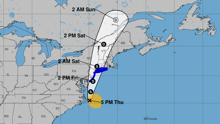
Tropical Storm Fay, a new system that just formed off the coast of North Carolina, is forecast to bring heavy rain, strong winds, and rough seas to Long Island on Friday.
The National Weather Service issued a tropical storm warning for Nassau and Suffolk counties. Fay is expected to bring up to three inches of rain, 50 mph winds, and dangerous rip currents to the region.
“This is primarily going to be a rain threat,” Da’Vel Johnson, an Upton-based NWS meteorologist, said. “We’re expecting quite a bit of rain starting at 6 a.m. and lasting through the whole day.”
New York City and the New Jersey coast are also under a tropical storm warning as the low pressure system churns northbound in the Atlantic. The storm is moving 7 mph and has a sustained wind speed of 45 mph.
“Exactly where the heaviest rains occur will be highly dependent on the low track, which remains uncertain,” the NWS said in a hazardous weather outlook.
“Torrential rainfall within a short period of time will be possible and this could lead to flooding of low lying, urban and poor drainage areas,” the agency added in a flood watch.
“Life-threatening rip currents are likely for all people entering the surf zone,” NWS also said in a rip current statement. “Anyone visiting the beaches should stay out of the surf. Rip currents can sweep even the best swimmers away from shore into deeper water.”
The strong winds may also down trees, branches, and utility wires, potentially causing power outages on LI. NWS added that the conditions are favorable for the potential formation of tornadoes when Fay arrives.
Sign up for Long Island Press’ email newsletters here. Sign up for home delivery of Long Island Press here. Sign up for discounts by becoming a Long Island Press community partner here.