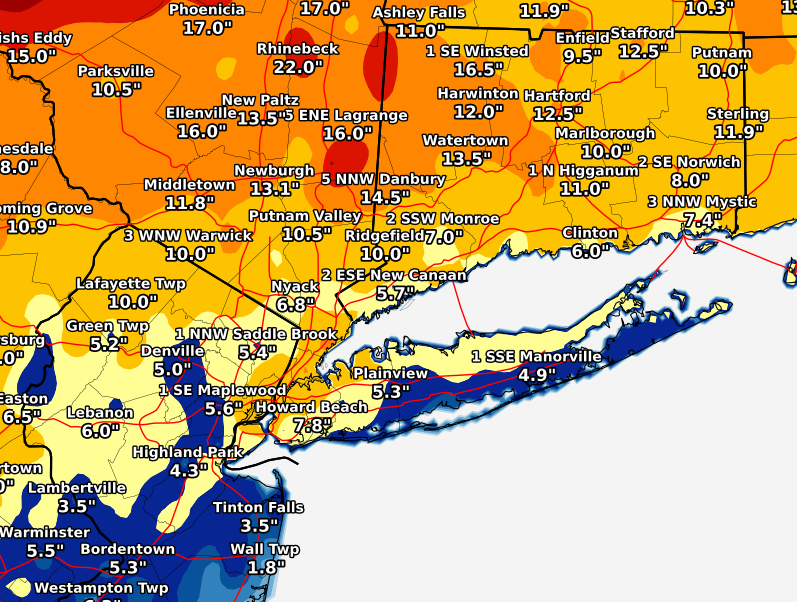
The first big winter storm of the season dumped more than 8 inches of snow on parts of Long Island overnight Wednesday into Thursday days before winter arrives Monday.
Although the National Weather Service forecast about a foot of snow for the region, the nor’easter fell a few inches short of that prediction, with 8.2 inches in Miller Place coming in as the highest accumulation on LI. Fears of strong winds downing utility lines and causing power outages also were not as bas as expected, with PSEG Long Island reporting nearly 3,500 of its 1.1 million customers losing power, which the utility said was mostly restored the same day.
“This storm brought down trees and wires throughout our service area,” John O’Connell, Vice President, Transmission & Distribution, PSEG Long Island. “We know that being without power for any length of time is a hardship and we thank our customers for their patience as we work through the damage and difficult conditions to restore their power safely and quickly as possible.”
Snow totals are as follows:
Suffolk
Miller Place: 8.2
Commack: 8.1
East Northport: 8.0
Nesconset: 8.0
Islip Airport: 7.4
E Yaphank: 7.0
Centerport: 6.9
Smithtown: 6.7
Calverton: 6.5
Stony Brook: 6.4
Orient Point: 6.0
Bay Shore: 5.7
Riverhead: 5.2
Remsenburg-Speonk: 5.2
Manorville: 4.9
Sayville: 4.5
West Islip: 4.0
Amityville: 3.5
Southampton: 3.3
Islip Terrace: 3.3
Nassau
Syosset: 8.0
Melville: 8.0
West Hempstead: 7.5
East Williston: 7.3
1 ENE Syosset: 7.0
East Meadow: 6.2
Farmingdale: 5.9
Merrick: 5.6
Plainedge: 5.5
Floral Park: 5.5
Plainview: 5.3
Roosevelt: 5.2