
The groundhogs were right: Wintry weather isn’t done with us yet.
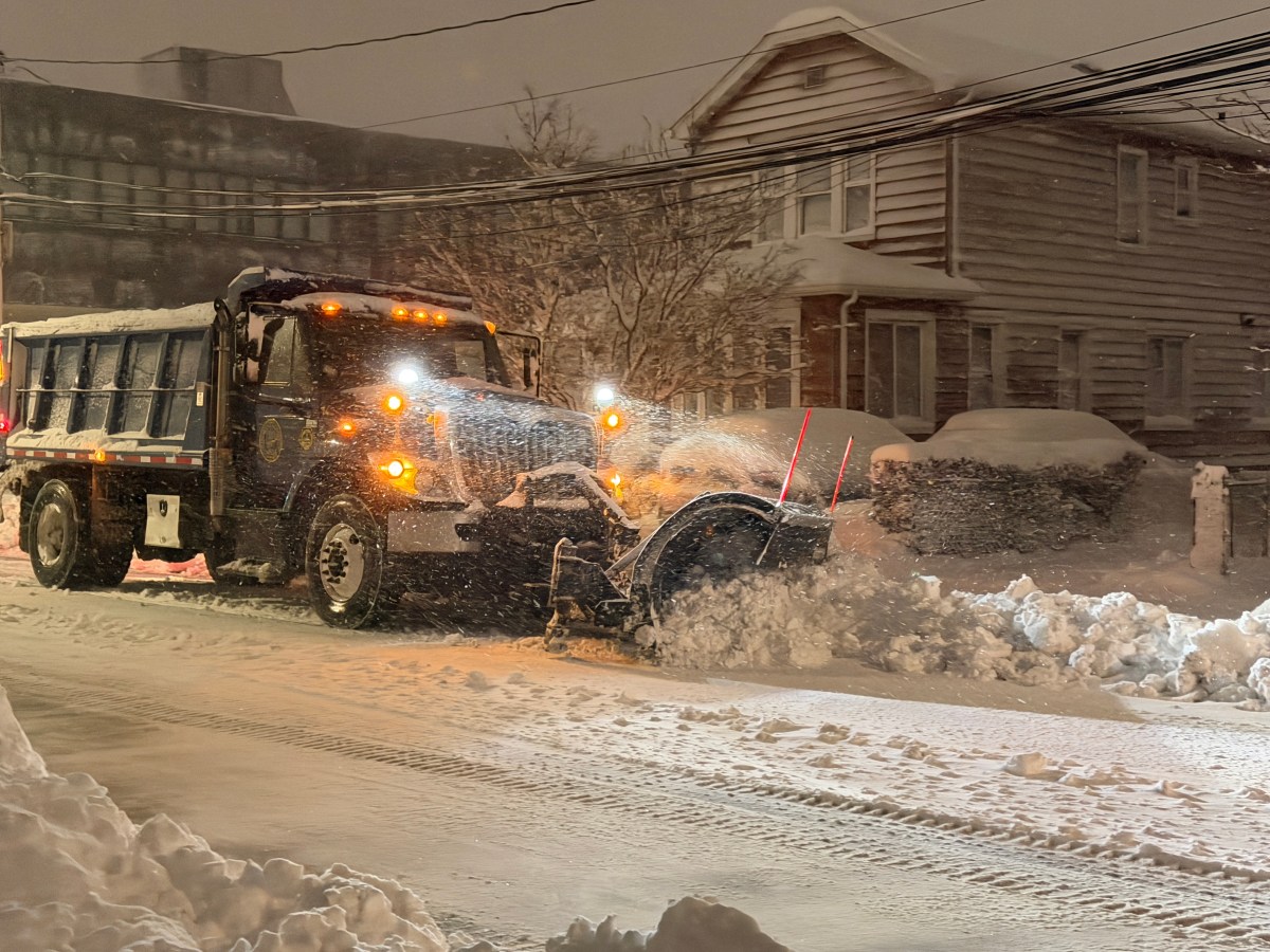
The most expansive local blizzard in a decade blanketed parts of Long Island with more than two feet of snow overnight Sunday, Feb. 22, into Monday, Feb. 23, according to the National Weather Service, which reported record-breaking snow accumulations of more than 29 inches in Islip and 84 mph wind gusts in Montauk. Gov. Kathy Hochul issued a state of emergency, as did many local municipalities, in advance of the blizzard’s arrival.
“It is a historic storm,” Nelson Vaz, an Upton-based NWS meteorologist, told the Press. “This is something that a generation will remember.”
The blizzard came as snow and ice had yet to fully melt from the last snowstorm that dumped over a foot of snow on the area on Jan. 25 before a deep freeze settled in, keeping the accumulation from melting. A repeat was initially expected this week due to black ice, followed by some gradual melting before more possible snow Thursday or Friday.
Nassau and Suffolk counties were also under a travel ban through Monday, with the exception of essential workers and plow operators. Many school district across Nassau and Suffolk counties canceled classes for Monday and Tuesday, tacking extra days onto the end of winter break. Flights were canceled and the Long Island Rail Road suspended service at 1 a.m. Monday, with limited service restored the following day.
PSEG Long Island warned that wind gusts could be “strong enough to potentially topple trees, bring down branches on wires and cause outages.” The utility said it has “personnel ready to respond safely and as quickly as possible throughout the storm.” There were more than 16,000 PSEG Long Island customers without power as of noon Monday, with less than 1,000 remaining the following day.
The storm also caused coastal flooding and beach erosion in waterfront areas. Damage reports included a snowplow that crashed onto its side on Sunrise Highway in Bay Shore, a vehicle hitting a fire hydrant and causing a flood in Speonk, and countless downed trees, some of which fell on vehicles or blocked roadways.
The 29 inches snowfall may be the most snow seen at Long Island MacArthur Airport in Ronkonkoma, the NWS’ official climate station for the region, since records were recorded there going back to the early 1960s. But that number did not eclipse the most snowfall count for one day on Long Island overall, which is is more than 30 inches, Vaz said.
Here are the NWS snow total reports as of 7:30 p.m.:
SUFFOLK
Central Islip 31″
East Islip 30″
North Patchogue 30″
Babylon 29.5″
Islip 29.1″
Holbrook 29″
Nesconset 28.8″
Shirley Airport 28.5″
Bay Shore 28.2″
Montauk 28.1 ”
Medford 27.8″
East Farmingdale 27.5″
Remsenburg-Speonk 27.5″
Orient Point 26.5″
Quogue 26″
Southampton 26″
Islip 25.3″
Lindenhurst 25″
Shinnecock Hills 25″
Bay Shore 24.7″
Lindenhurst 24.3″
Davis Park 24.2″
Babylon 24″
Ridge 24″
Southampton 24″
Islandia 23.5 ”
Mattituck 23.3″
Flanders 23″
Hauppauge 23″
Islip Terrace 23″
Lake Ronkonkoma 23″
Middle Island 23″
West Islip 22.8″
Manorville 22″
Shelter Island 21.1″
East Northport 21″
Ridge 20.7″
Oakdale 20.5″
Riverhead 20.2″
East Patchogue 20″
Nesconset 20″
Upton (NWS Office) 19.8″
Riverhead 19.7″
Stony Brook 19.7″
Ridge 19.6″
Amityville 19″
Commack 19″
Bellport 18″
Smithtown 17″
Rocky Point 17″
Jamesport 16.6″
Copiague 16.5″
Centerport 16″
Islip Terrace 15″
Northport 15″
Greenlawn 11.3 ”
NASSAU
North Merrick 25.4″
East Massapequa 24.5″
Bethpage 24.4″
East Massapequa 24.4″
Lynbrook 24″
Plainview 23.8″
East Meadow 23.7″
Plainview 23.2″
South Massapequa 22.4″
Wantagh 22″
Elmont 21.5″
Bellmore 21″
Glen Cove 19″
Levittown 19″
Malverne 18.5″
Westbury 18″
East Williston 16.9″
Syosset 16.3″
Sea Cliff 15.8″
Jericho 15.2″
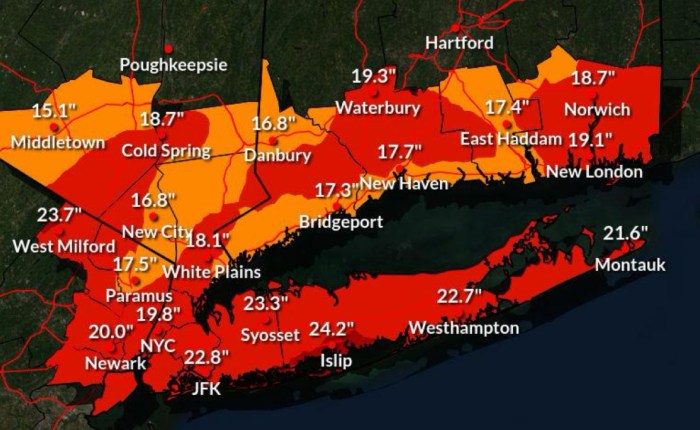
This was the last NWS forecast snow total map for the Blizzard of 2026 before the storm hit. (NWS)
Related story: Guide to Long Island’s Coolest Sledding Spots
Send snow photos to letters@longislandpress.com