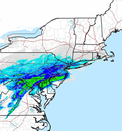
The winter storm threatening to dump more than a foot of snow on Long Island Tuesday could be at its worst at the tail end of the evening commute and into the overnight hours on Wednesday, meteorologists said.
A winter storm warning is in effect for both Nassau and Suffolk counties from noon until 6 a.m. Wednesday, according to the Upton-based National Weather Service, which is predicting between 10 to 14 inches of snow and possible sub-zero temperatures.
Conditions will “deteriorate through the rest of the day, mostly through the afternoon,” said NWS meteorologist Tim Morrin.
He warned that the coastal storm will be at its “absolute worst” between 7 p.m. and 4 a.m. Wednesday.
“That doesn’t mean the evening rush will be a piece of cake either,” Morrin added.
With significant snowfall on its way, the weather service said travel will be dangerous, warning drivers that visibility could be at a quarter of a mile or less starting in the afternoon.
Falling and blowing snow will cause “hazardous travel and walking conditions across the area,” the agency said.
When asked if Gov. Andrew Cuomo has any plans to close the Long Island Expressway or any other state roads like he did earlier this month, a spokeswoman said: “We’re monitoring the storm closely and will issue updates as we have them.”
Temperatures are expected to drop into the lower teens Tuesday night, forecasters said. But, sustained winds between 15 to 25 mph and gusts as high as 35 mph could produce bone-chilling temperatures possibly as low as 10 below zero.
Light snowfall started around 8 a.m. Tuesday, but it should pick up in intensity during the afternoon, the weather service said.
The New York State Department of Transportation website was reporting several accidents during the morning commute, though its unclear if they were weather related.
Many state roads in Nassau and western Suffolk were experiencing snow/icy conditions Tuesday morning.
Tavel on the Long Island Rail Road didn’t appear to be hampered by the early snowfall, though the railroad could modify or suspend train service if snowfall reaches 10-13 inches or more, according to LIRR’s weather guide.
Long Island MacArthur Airport reported Tuesday that all flights after 3:15 p.m. have been cancelled:
All commercial #flights scheduled after 3:15 today have been cancelled. #Travelers advised to check with carrier for latest info. #Airlines
— LI MacArthur Airport (@LIMacArthur) January 21, 2014
PSEG Long Island, which took over LIPA’s electric grid at the beginning of the year, said it was preparing for the storm by performing system checks on critical transmission and distribution equipment and arranging for contractors, including tree crews, to assist the utility’s storm response.
“The potential heavy snow, icing and strong winds are what increases the possibility of downed wires and associated power outages,” PSEG Long Island said. “Cars striking utility poles can also cause wires to come down.”
The storm will taper off by Wednesday morning, but temperatures will remain well below freezing, according to the weather service.