
 A new time-lapse video of Earth has gone viral, providing beautiful views of Earth to all of its Internet-using inhabitants.
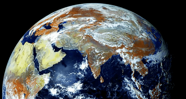
The video shows off Earth’s Northern Hemisphere, which houses most of the planet’s land and human population, with crystal clear and vibrant colored images.
The magnificent footage is provided by Electro-L, a geostationary weather satellite that is orbiting 131,233,596-feet above Earth. The satellite reportedly creates a 121 megapixel image every 30 minutes with four visible and infrared light wavelengths.
“The infrared light appears orange in these images, and shows vegetation,” reads the YouTube video caption.
The pictures were taken in 2011, from May 14 to May 20 and come as the largest whole disk images of the planet we call home, with a resolution of 1 kilometer per pixel.
Viewers notice that the images are masked by a circular barrier that blocks out the light of the Sun and other stars “to prevent damage to the camera by exposure to direct sunlight,” the video caption states.
This impressive video follows a slew of similarly stellar time-lapse videos released last year. Back in November, a video was released by Michael Konig who linked thousands of NASA photos taken at the International Space Station together to form one breathtaking time-lapse video of Earth.
The video followed an amazing time-lapse video that was released in September featuring the Southern Lights. The video featured thousands of stunning shots of the Southern Lights, better known as Aurora Australis, taken by NASA.
In April, a passenger flying from San Francisco to Paris captured amazing images of Aurora Borealis, or the Northern Lights and turned them into a captivating time-lapse video. Nate Bolt took the shots 30,000 feet out of the window of a flight he was on with his long exposure camera during the flight, not knowing that he had caught footage of the natural phenomenon.
Check it out.