Just the thought of what’s coming this weekend has us shivering in our pants.
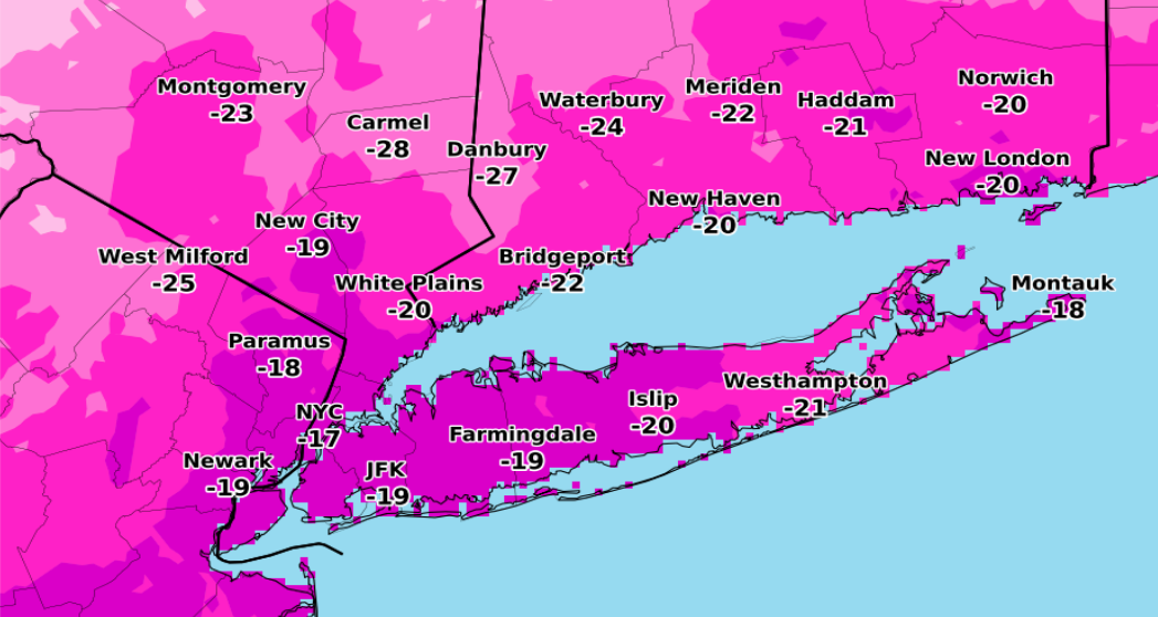
The National Weather Service in Upton said Long Islanders should expect “dangerously cold” conditions beginning overnight Saturday with subzero temperatures and wind chill values close to -20 across the Island.
The blustery conditions can be blamed on an “arctic outbreak” making its way to the region this weekend.
NWS meteorologists said in a weather briefing that the coldest time period will be from late Saturday through Sunday morning.
Saturday’s forecast calls for a high near 22 during the day but the temperature will steadily drop into the lower teens as the day progresses. Eventually the mercury will plummet to around -5 degrees at night. What’s more, the wind chill could make it feel like -20, forecasters said.
The arctic blast will hang over the Island on Sunday—meaning Valentine’s Day revelers will have to bundle up to enjoy the festivities. Temperatures on Sunday are expected to hit the teens but won’t go much higher than that, the weather service said.
The agency is advising residents to pack on layers and make use of gloves and hats to prevent the loss of body heat.
The deep freeze could cause serious health issues like hypothermia, the weather service warned. Symptoms include confusion, dizziness, exhaustion and severe shivering, the weather service said.
A reprieve from bone-chilling temperatures could come as early as next week. Monday’s forecast calls for sunny skies with a high near 35. Things only get better from there with back-to-back days of temperatures in the low 40s, forecasters said.
Much colder, possibly record breaking temperatures in store for the weekend.
Posted by US National Weather Service New York NY on Wednesday, February 10, 2016