With Hurricane Joaquin threatening the East Coast, Long Island officials began urging the public to prepare for the worst despite the storm’s uncertain path as it reached major hurricane status Thursday.
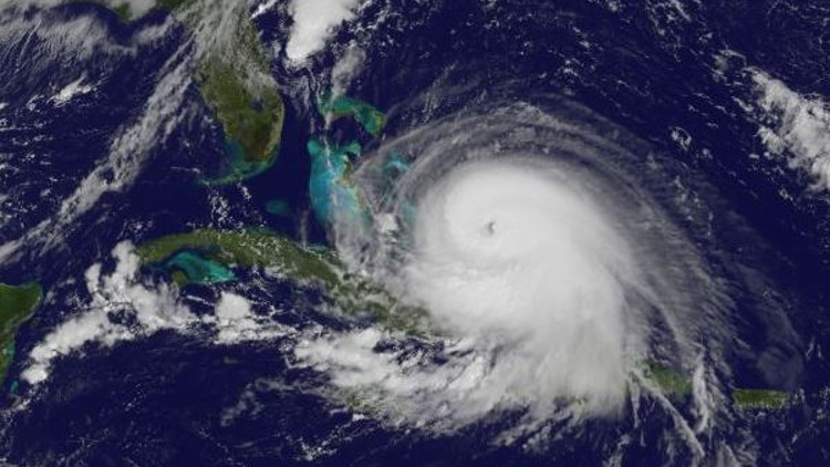
The National Hurricane Center upgraded Joaquin to a Category 4 hurricane with 130 mph sustained winds, terming it “extremely dangerous.” It was expected to batter the central Bahamas overnight. As for where Joaquin will hit next, meteorologists are grappling with major unknowns due to the myriad atmospheric conditions in play. The intensifying storm could make landfall in the Northeast or veer further into the Atlantic, sparing significant coastal damage.
“Right now we’re essentially in a ‘prepare and pray’ mode,” Suffolk County Executive Steve Bellone told reporters during a press conference at police headquarters in Yaphank. “We’re gonna prepare for a worst-case scenario; we’re gonna pray that it does not unfold.”
Although the National Hurricane Center said a hurricane watch may not be issued for the East Coast until Friday at the earliest, the National Weather Service issued a coastal flood watch and high surf advisory through 6 a.m. Friday to start. Astronomically higher than usual tides are forecast to cause barrier beach erosion and flood coastal homes.
The message from officials in both Nassau and Suffolk counties is to stay informed, have go-kits ready for residents in low-lying areas, stock up on enough food and water that would last at least three days, gas up vehicles and generators, and heed evacuation warnings, if any are issued, so as not to put first responders unnecessarily in harm’s way.
“The county is prepared to respond,” Nassau County Executive Ed Mangano said Thursday morning during a press conference at the Nassau County Office of Emergency Management in Bethpage.
The county executive expressed confidence in a rapid and efficient reaction if the storm strikes, noting that Nassau learned from Superstorm Sandy, which hit LI three years ago this month. He added that residents also have to play their part, because early preparation prior to Sandy “saved lives.”
Both Mangano and Bellone said their counties have more assets to help tackle the storm than they did during Sandy, touting dozens of high-axle vehicles used for flood rescues, portable traffic lights for blackouts and a slew of new emergency generators. One of the major issues in the early days following Sandy were the power outages that knocked out traffic lights, making roads very dangerous. An increase in portable traffic lights should help alleviate that problem, Mangano noted.
Local municipalities are also calling residents to be vigilant. Town of Hempstead said it’s preparing equipment for a potential storm and urged boaters to begin removing their vessels from marinas.
“It is critical for each and every one of us to formulate a hurricane preparedness plan, and to be ready when and if the storm arrives,” said Town of Hempstead Supervisor Kate Murray.
In Brookhaven Town, supervisor Ed Romaine informed residents that they should visit the town’s website for news and weather updates, and also to access its “Hurricane Survival Guide.”
Calling for the public to be proactive, Islip town officials not only cited Sandy’s aftermath, but also invoked the “unprecedented and unpredicted” storm in August 2014 that flooded neighborhoods with a record-setting 13 inches of rainfall, the most ever measured in a 24-hour period statewide.
If a major tropical storm does hit LI, it would be the first true test for PSEG Long Island since it took over for the Long Island Power Authority in January 2014 amid outrage over LIPA’s inadequate response to Sandy. The utility said it’s monitoring Hurricane Joaquin and is preparing for a potential deluge of rain and powerful wind gusts. Resources will be in place over the weekend to initiate electric service restoration “as soon as the storm passes,” PSEG LI said in a statement.
Officials remain concerned about LI’s Sandy-battered infrastructure. For example, construction is ongoing at Bay Park Sewage Treatment Plant, which suffered a catastrophic failure during Sandy. Mangano said the county will use sandbags as an added layer of protection around the plant because a planned storm wall is still being built. Pumps have also been installed to keep pumping sewage away from people’s homes, the county executive said.
On the other side of the county line, Bellone expressed concern that the dunes on Fire Island have yet to be restored since they were flattened by Sandy, which puts coastal communities on the Great South Bay at risk of flooding. Fire Island Ferries, the largest boat service to the mostly car-free barrier island, said it plans to suspend service Sunday.
Meanwhile, without knowing where Joaquin will go next, Gov. Andrew Cuomo told all New Yorkers to get ready for the hurricane.
“Since we don’t know if the storm is downstate or upstate, you have to prepare statewide,” Gov. Andrew Cuomo reporters on a conference call Thursday.After Sandy,many upstate communities were devastated by severe flooding that left bridges impassable for days, if not weeks.
The governor said it’s too early to tell what major roads, if any, will be closed or whether mass transit will be shut down in New York City and on Long Island as it was during Irene and Sandy.
He added that maintenance crews are clearing problem areas in streams and conduits that have proven problematic in past storms, as emergency management offices are being activated statewide and are coordinating with utility agencies, “especially on Long Island.”
Cuomo said that experience with prior hurricanes have helped the state better prepare for tropical cyclones. But he cautioned that Mother Nature always finds a blind spot.
“You can’t be prepared for everything,” he warned.
One thing’s for sure, more rain is definitely heading toward LI, with heavy downfall expected Friday morning and possibly through the weekend along with strong winds.