Five years after Sandy breached Fire Island, the new channel between the Atlantic and Great South Bay is shifting, but stable and unlikely to increase bay-front storm flooding, a new study found.
The U.S. Geological Survey (USGS) made the findings in what the federal agency billed as one of the most detailed scientific studies ever conducted of the early stages in the life of a barrier island breach.
“Storm strikes are the force that drives the geomorphology—the geologic shape and evolution—of barrier islands along the Northeast coast,” said Cheryl Hapke, a USGS oceanographer, FI erosion expert and lead author of the report released last month. “But until this event, no one ever had the opportunity to watch a breach open and evolve, and to study that process in depth.”
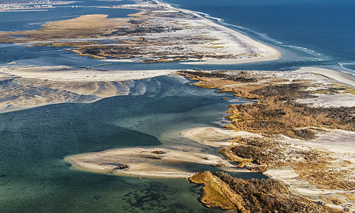
The breach is in the 7-mile-long Otis Pike High Dune Wilderness, the only federally designated wilderness in New York State, on the eastern half of the Fire Island National Seashore. It is one of three Long Island barrier beach breaches—one near Smith Point on FI, the other at Cupsogue County Park—that the Oct. 29, 2012 superstorm caused, but the other two were filled in with sand.
The remaining breach opened in an area of FI known as Old Inlet, where a gap in the barrier island was open from 1763 to 1825. The study found that the new breach followed the path of a boardwalk destroyed by Sandy, suggesting the lack of vegetation under the boardwalk may have contributed to the breach since there was little to slow the wave action.
The day before Sandy struck, researchers gathered data on the island’s geology using what’s known as lidar—laser pulses that reveal surface contours more precisely than radar. They also examined data from a National Oceanic and Atmospheric Administration buoy 30 miles off the southern coast of FI that recorded a 31 ½ foot wave during the storm.
The original 177-foot opening widened to 1,879 feet, or nearly one-third of a mile, after seven nor’easters struck LI in the year following Sandy, the report found. The breach moved west and grew rapidly until it reached what researchers described as “a state of near-equilibrium” 18 months after the storm.
Sediment from that part of the island, which was scoured out at a depth of 13 feet, formed a delta and shoals on the bay side of the breach, according to the study. The shoals continue to shift as big storms hit the area, usually between fall and spring.
Researchers noted that a study based on USGS-led data collection found that high tides arrive slightly earlier than they did before due to the increased rate of water flowing through the breach, creating the potential for floodwaters to increase up to three inches in the eastern part of the bay during storms. But they added that the majority of water flowing into the bay—storm or not—comes from pre-existing inlets.
The scientists noted that breaches are naturally occurring and can improve the quality of water in the bay by flushing out pollutants. They also said the goal of the study was to understand how the breach evolved, anticipate its effects on surrounding areas and predict what may happen in future storms. The study was provided to FINS’ parent agency, the National Park Service, to help officials develop a plan for managing the breach.
During the Fire Island Association’s summer meeting in Ocean Beach, FINS Superintendent Chris Soller said the seashore doesn’t have any plans to close the breach and is instead continuing to take a wait-and-see approach, although officials previously put plans in motion in case they needed to fill it in.
“How soon it’s going close is anybody’s guess,” he said.