The number of tornadoes that touched down Saturday on Long Island increased to six, as the National Weather Service confirmed twisters in North Bellport and from Hampton Bays to North Sea.
The agency previously confirmed tornadoes left a trail of destruction from Woodmere to Levittown, East Islip to Oakdale, Shirley to Manorville, and Remsenburg to Westhampton. The most powerful of the three was the Manorville tornado, which was confirmed as an EF1 on the Enhanced Fujita Scale that ranks tornado strength, with 110 mph winds, while the other five were ranked as an EF0, the weakest on the scale, with estimated 85 mph winds each.
“It was unprecedented for the region to see that many tornadoes,” said Dominic Ramunni, an Upton-based NWS meteorologist, noting that the NWS’s weather record for LI began in 1950. Suffolk County Executive Steve Bellone declared a state of emergency to help expedite funding for the cleanup efforts.
The tornadoes hit Long Island during fast-moving thunderstorms that brought strong winds, heavy rains, and hail to the region. NWS performed field surveys with local emergency service crews at hard-hit locations to assess the damage. There were no injuries or fatalities reported in any of the tornadoes.
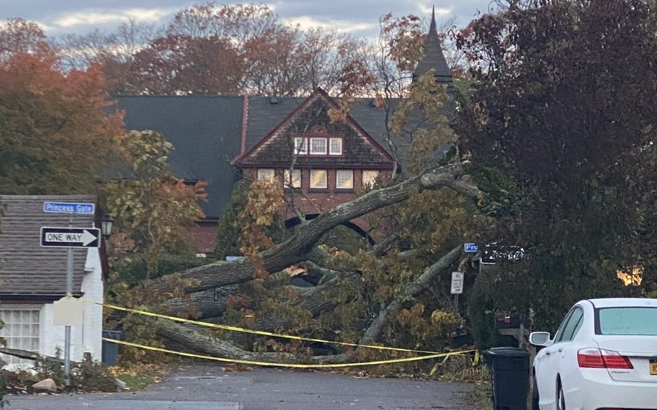
The first of the three was the one in Nassau and lasted 18 minutes, although it was only on the ground for a total of about a quarter of a mile. The 50-yard-wide twister first briefly touched down at 2:37 p.m. in Woodmere, where it downed trees and power lines, then lifted and traveled 50 mph to Uniondale, where it touched down again and tore a roof off a two-story structure, the NWS reported. The roof landed on a nearby house, with shingles, insulation and siding scattered across two blocks. The tornado then skipped over to Levittown, where it knocked large trees onto houses before it lifted at 2:55 p.m.
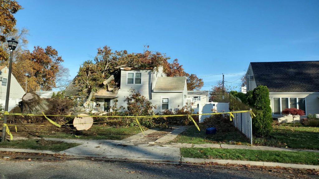
The second tornado was the shortest of the three, clocking in at just two minutes. It was also 50-yards-wide when it touched down at 3:20 p.m. on Hollins Lane in East Islip and continued to the the John F. Kennedy Elementary School sport fields, where it lifted and became a funnel cloud, NWS reported. It uprooted a few dozen large trees, snapped the trunks of others, and caused roof and siding damage to several homes and may have briefly touched down again as a weak tornado at Jade Street in Oakdale, “resulting in a very large, but partially rotted, oak tree to topple onto and destroy a home,” NWS reported.
“The funnel cloud was videotaped by the public, looking southwest from the Old Navy department store on Johnson Avenue … but no further damage was noted with this storm,” NWS reported, adding that it was on the ground for about 900 yards.
The third and strongest tornado caused the most damage and ran a length of 3 ½ miles. It first touched down at 3:42 p.m. near Francine Place and Mastic Boulevard in Shirley, where it downed trees and damaged homes, starting out as about 25 yards wide, NWS reported.
“The tornado then hooked northeast over the Lidl supermarket … flipping over a 5-ton air handler unit on the roof, before tearing off the parapet and collapsing the covered walkway of the Chipotle Mexican grill on the northeast corner of the shopping center,” NWS stated in its preliminary assessment. “Public video showed the apparent tornadic circulation lifting northeast across the intersection of William Floyd Parkway and Montauk Highway towards the Applebees shopping center, with debris being thrown in one direction then another.”
The tornado may have lifted briefly before it then touched down again, lifted the roof off a two-story multifamily residence, and tossed the roof 150 yards into a neighboring backyard, with one section of this roof impaled into the side of the neighboring house “and made such a strong impact that it skewed the vertical structure of that house,” NWS reported.
“The tornado strength likely peaked at this point,” the agency’s report stated, adding that the tornado then crossed Sunrise Highway, “skipping its way northeast for the next 4 1/2 miles.”
It passed through Brookhaven Calabro Airport, flipping over or shifting a few small single engine planes, according to the agency. It then traveled through residential neighborhoods, causing damage consistent with an EF0 tornado with 85 mph winds, before it lifted in Manorville eight minutes after it started.
“Numerous tree tops were sheared and tree trunks snapped with minor roof, siding and fencing damage observed for numerous houses along this path,” NWS reported. “A large camper … on Tupelo Drive was rolled onto its side.”
The tornado that traveled from Remsenburg to Westhampton started at 3:53 p.m., minutes after the Manorville twister, and traveled 3.5 miles in seven minutes, NWS reported.
Believed to be a narrow tornado 35 yards wide, it touched down at the corner of Ring Neck Road and South Country Road, then continued northeast, up to Montauk Highway, uprooting several large trees and damaging utility wires and causing minor damage to the exterior of several homes along the way, NWS reported.
“The most extensive structural damage occurred at the end of the visible tornadic path at the [county] Department of Public Works salt barn on south perimeter road on the south side of Westhampton Gabreski Airport,” the NWS assessment stated. “The north-facing reinforced cinder wall of the salt barn was blown out. Indications are the roof may have briefly lifted as south to southwest winds with the tornadic circulation blasted into the south-facing opening, culminating in the north wall being blown out.”
Even first responders accustomed to dealing with the impact of significant coastal storms and hurricanes were taken by surprise.
“It came and went in a flash,” said Mauro DiBenedetto, the first assistant chief of the Westhampton Beach Fire Department. “The same things that happen during a hurricane happened. We’re experienced with wires down … but not in an instant.”
Bellone, after touring the barn that stores road salt that snow plows use to clear East End roads after winter storms, noted that the region was caught by surprise.
“There was not a significant amount of warning at all for this storm,” Bellone said. “The first warning was issued just a short time before the first tornado touched down here.”
The North Bellport tornado touched down in a pine tree forest south of Sunrise Highway at 3:40 p.m., knocked over the Exit 56 sign on its way to the Brookhaven landfill and blowing off the roof of the Brookhaven Recycling Center, NWS reported.
The tornado that started in Hampton Bays and ended in North Sea was the sixth on LI and the third on the East End to be confirmed by the NWS.
The agency confirmed its occurrence on Tuesday night, but details of the damage it caused or evidence that investigators used to verify it were not immediatly available.
These are the first tornadoes to touch down on LI since one was confirmed in Manorville in 2019. A year prior to that the Island saw two tornados a month apart on Fishers Island and in Ronkonkoma. A small tornado hit Mattituck in 2016, and another traveled from Great River to Lake Ronkonkoma in 2012. The last time three tornadoes hit LI on the same day was June 30, 1998.
While the tornadoes made for some scary stories — areas not hit by tornadoes also often experienced strong straight-line winds, torrential downpours and in some places, hail — there were no reported injuries or fatalities, although PSEG Long Island reported about 30,000 of its 1.1 million customers lost power. And they were relatively weak compared to stronger tornadoes that hit Middle America, where EF5 tornadoes with winds of more than 200 mph level homes.