
Torrential downpours caused serious flooding and road closures across parts of Long Island early Sunday morning into the afternoon.
Almost six inches of rain was reported in areas of Long Island with the south shore suffering some of the worst flooding.
Early Sunday, the National Weather Service issued a flash flood watch for both Nassau and Suffolk, which was updated to a warning by noon. Forecasters expect an additional two to four inches of rainfall through Monday evening.
Drivers were affected by the inclement weather. Nassau and Suffolk county police reportedly rescued
multiple drivers stuck in flooded roadways Islandwide.
“Periodic intense downfalls of rain are causing flooding and accumulating pooling of water along roadways. Motorists should be advised NOT to drive through standing water on roadways,” advised Nassau County Police in a statement.
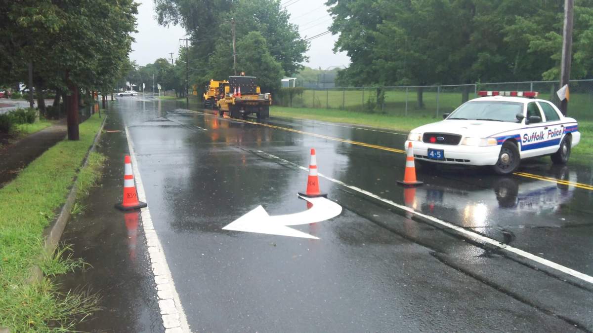
Roads were closed throughout Nassau County. Currently, Wantagh Parkway is closed between Sunrise Highway and the Southern State Parkway in both directions. Meadowbrook Parkway is closed between Babylon Turnpike and Southern State Parkway is closed in both directions. Seaford Oyster Bay westbound exit ramp at Merrick Road is closed.
Earlier, the North Service Road east and west of Mineola Avenue as well as South Service Road east of Shelter Rock Road were closed but are now open. Also, Sunrise Highway was closed in both directions at Old Sunrise Highway but is now opened.
Suffolk County police said that Wheeler Rd in Hauppauge is seeing flooding and delays. Sections of NY 110 in Huntington were closed as well.
NWS forecasters in Upton has issued a flood advisory for Suffolk County until 5 p.m.
At 4 p.m. doppler radar was tracking strong thunderstorms along a line extending from Calverton to 14 miles southeast of Davis Part to 15 miles southeast of Robert Moses State Park, or along a line extending from Manorville to 18 miles southeast of Patchogue to 15 miles southeast of Robert Moses State Park and moving north at 25 MPH.
These storms will be near Davis Park by 4:35 p.m., Mastic Beach by 4:45 p.m., Center Moriches by 4:50 p.m., Mastic by 4:55 p.m., Manorville by 5 p.m., Yaphank by 5:05 p.m. Very heavy rain with rainfall rates up to two inches an hour is expect with these storms. This will cause pondering of water on roadways.
The downpours also caused power outages and train delays across LI.
According to LIPA, more than 2,000 resident’s power was affected Sunday, with 89 customers remaining without power.
Long Island Rail Road train service is suspended on the Far Rockaway and Long Beach branches due to weather-related signal problems. According to MTA, buses are being subsituted for trains on Far Rockaway brand and Long Beach branch. Oyster Bay and Port Jefferson branches, as well as Ronkonkoma line were also effected by flooding and are currently delayed.
New York City is also impacted by the flooding, which is due to a storm in the Mid Atlantic Coast.