
Earlier, meteorologists predicted showers and thunderstorms with some of the storms producing heavy rainfall, but it looks like there’s more severe weather for Long Island tonight.
According to the National Weather Service, a severe thunderstorm warning remains in effect until 4:45 p.m. for Nassau County and a severe thunderstorm watch in effect until 9 p.m. for Southeast New York.
The warning follows a storm that was located southeast of Sheepshead Bay, near Rockaway Beach that’s moving northeast. The storm is reportedly capable of producing quarter size hail and damaging winds up to 60 MPH.
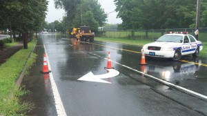
Last Sunday, storms brought torrential rains to the region. The rains were record-breaking with nearly 11 inches reported in Lido Beach. The storm caused major flooding along with road closures, power outages and train delays.
The Nassau and Suffolk county police rescued multiple drivers stuck in flooded roadways Islandwide. According to LIPA, more than 2,000 residents’ power was affected Sunday, and the Long Island Rail Road experienced multiple line delays and suspensions. Some outages and delays lingered into mid-day Monday.