California Earthquake: Earthquake Shakes Southern California
By Alexander CapognaPosted on
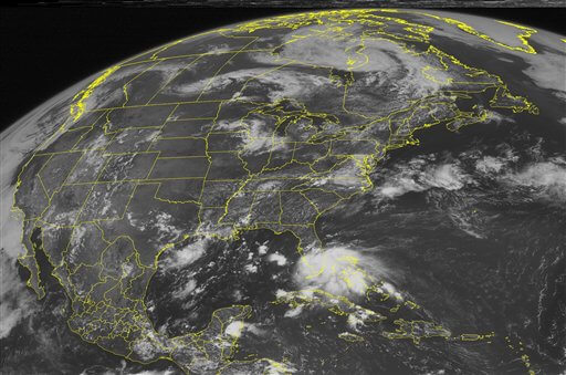
This NOAA satellite image taken Sunday, July 22, 2012, at 01:45 PM EDT shows dense cloud cover over southern Florida, as numerous showers and a few strong thunderstorms form over the northwestern Bahamas, south Florida, the Florida Keys, the adjacent Atlantic waters and the Florida Straits. Thunderstorm activity continues to increase today with strong wind gusts through the afternoon. This system has a low chances of becoming a tropical cyclone by Tuesday afternoon as it heads northwestward at about 15 mph into the Gulf of Mexico. Meanwhile, deep moisture spreads across the Gulf of Mexico coast and stirs up rain and thunderstorms in southern Louisiana. To the north a frontal boundary remains stalled across the Mid-Atlantic through the afternoon. Moisture pooling along this front maintains a few areas of light to moderate rain showers in the region. Further north, a frontal boundary extends from southeastern Canada through the Great Lakes and into the Northern Plains. Waves of energy propagate eastward near the front, stirring up showers and thunderstorms in northern Illinois and Iowa. Areas from northern Minnesota into parts of northern Wisconsin and parts of Michigan’s Upper Peninsula remain at slight risk of severe thunderstorm development with damaging wind gusts and hail. Elsewhere, hot temperatures continue from the Southern Plains into the Northern Plains and eastward across the Mid-Mississippi Valley and into the western Ohio Valley. Red Flag Warnings and Heat Advisories remain in effect for much of these areas as daytime highs climb into the 90s and lower 100s. (AP Photo/Weather UndergroundD)
This NOAA satellite image taken Sunday, July 22, 2012, at 01:45 PM EDT. (AP Photo/Weather UndergroundD)
A series of quakes shook up parts of Southern California late Tuesday night.
Officials said a 4.4-magnitude earthquake was centered 35 miles southeast of Los Angeles and two miles east of Yorba Linda. Initial tremors began at 11:23 p.m., 5.1 miles below the surface, according to reports published by the U.S. Geological Survey.
About two minutes later, a second quake originating from the same epicenter, registered at a 2.7-magnitude. A 1.2-magnitude tremor was also recorded. At least half a dozen aftershocks struck within two miles of the initial quake in northern Orange County between midnight and 3 a.m. Wednesday.
Matt Spence of the Los Angeles Fire Department confirmed in an email statement sent immediately after the first quake struck fire officials had put into effect “Emergency Earthquake Mode,” according to NBC News. Firefighters from a total 106 local departments were mobilized to examine residential and public structures across the Greater Los Angeles area.
Neither the Los Angeles Fire Department nor the Orange County Fire Authority reported any serious injuries or infrastructural damage, and by 12:15 a.m., the emergency procedure was universally lifted.
Reports from locals who claimed to have felt the quake came in no short supply.
“I suddenly heard a loud thud coming from what sounded like the roof on my garage and then the whole garage started shaking and creaking,” one resident of Burbank told NBC.
Replies to the USGS “Did You Feel It?” inquiry include reports from hundreds of residents who experienced the quake from as far away as Anaheim, Rancho Santa Fe, Palm Springs, and San Diego. One response came from as far away as Las Vegas.