

NASA confirmed that the satellite, Upper Atmosphere Research Satellite (UARS), landed in the Pacific this past week.
The 6 ½ ton satellite fell back to Earth at 12 a.m. Saturday, September 24 west of the United States.
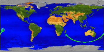
According to NASA, The Joint Space Operations Center at Vandenberg Air Force Base in California determined UARS entered the atmosphere over the Pacific Ocean (at 14.1 degrees south latitude and 189.8 degrees east longitude) over a remote ocean area in the Southern Hemisphere—Luckily, the location was reportedly far from land, which wasn’t ruled out as a possibility last week as scientists tried to predict it’s landing location.
Reportedly, the debris field is located ranges from 300 miles and 800 miles northeast of the re-entry point although NASA reportedly has not received any word of debris sightings.
UARS first launched in 1991 to observe varying chemical components of the atmosphere and take long-term records. The satellite stopped its scientific life six years ago and has since, started falling back to Earth. The bus-sized satellite was expected to break into pieces during re-entry, with most burning up in the atmosphere. Scientists predicted that 26 pieces, ranging from two pounds to about 300, would be able to survive re-entry and reach Earth’s surface.
The last time a spacecraft as large as UARS fell back into Earth uncontrolled was when Skylab fell in western Australia in 1979.