

The groundhogs were right: Winter isn’t done with us yet.
All eyes on yet another snowstorm — this time one that may bring blizzard conditions — that could blanket parts of Long Island in more than a foot of snow this weekend, forecasters say.
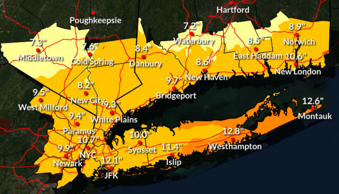
The National Weather Service issued a winter storm watch for Nassau and Suffolk counties from Sunday morning through Monday afternoon, when snow accumulations of 10 to 13 inches and wind gusts up to 45 mph may hit the region. The agency also issued a coastal flood watch for waterfront areas.
“Blizzard conditions are possible across central and eastern LI,” Upton-based NWS meteorologists declared.
“Travel could be very difficult to impossible,” the agency said in the storm watch. “Areas of blowing snow could significantly reduce visibility. The hazardous conditions could impact the Monday morning and evening commutes. The combination of gusty winds and heavy wet snow could bring down tree branches.”
Much of the tristate area is under the same storm watch, which comes as snow and ice has yet to fully melt from the last snowstorm dumped over a foot of snow on the area on Jan. 25 before a deep freeze settled in, keeping the accumulation from melting. AccuWeather reported that the accumulations this time would be higher on the East End with the possibility of up to 18 inches of snow.
The flood watch pertains to low-lying shoreline areas that forecasters say could see inundation up to 2 ½ feet above ground level Sunday evening through late Sunday night.
“This would result in numerous road closures and cause widespread flooding of low-lying property including parking lots, parks, lawns and homes/businesses with basements near the waterfront,” NWS stated. “Vehicles parked in vulnerable areas near the waterfront will likely become flooded. Flooding will also extend inland from the waterfront along tidal rivers and bays. Ice cover in the bays and harbors could exacerbate flooding and cause damage to northeast to east facing shoreline structures.”
Beach and dune erosion, especially at high tide, are likely, with possible wash overs in compromised dune areas.
“This water level forecast will be highly dependent on timing of windshift from east northeast to north gales with respect to the time of high tide, and will be refined over the next 24 hours,” the agency added. “Ice cover in the bays and harbors could exacerbate flooding and cause damage to northeast- to east-facing shoreline structures.”
PSEG Long Island warned that wind gusts up to 55 mph on the East End could be “strong enough to potentially topple trees, bring down branches on wires and cause outages.” The utility said it has “personnel ready to respond safely and as quickly as possible throughout the storm.”
Related story: Guide to Long Island’s Coolest Sledding Spots