
Friday brought good news for Long Islanders as meteorologists were provided a clearer understanding of Hurricane Joaquin’s path—which, for the time being, does not include Long Island.
“The forecast models continue to indicate a track offshore of the United States east coast from the Carolinas to the mid-Atlantic states, and the threat of direct impacts from Joaquin in those areas is decreasing,” the National Hurricane Center said.
Locally, the Upton-based National Weather Service said on its Facebook page that the latest update “is still showing Hurricane Joaquin to be passing far offshore.”
8AM update is still showing Hurricane Joaquin to be passing far offshore.
Posted by US National Weather Service New York NY on Friday, October 2, 2015
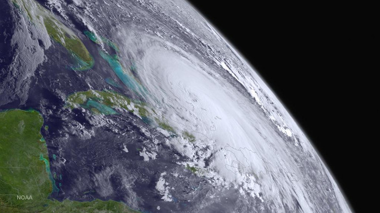
But that doesn’t mean the region won’t be impacted by Joaquin, which is currently battering the Bahamas for a third consecutive day as a category 4 hurricane with maximum sustained winds of 130 mph.
“Even if Joaquin remains offshore, strong onshore winds associated with a frontal system will create minor to moderate coastal flooding along the coasts of the mid-Atlantic and northeastern states through the weekend,” the National Hurricane Center said.
Extremely dangerous Hurricane Joaquin is moving slowly northwestward as it batters the Central Bahamas for a third day….
Posted by NOAA NWS National Hurricane Center on Friday, October 2, 2015
The Island is currently under a coastal flood advisory until 3 p.m. Friday and a high surf advisory until 6 p.m. Sunday, according to the weather service.
The forecast for Friday calls for up to a half an inch of rain and breezy conditions. Temperatures will remain in the mid-50s, forecasters said.
More wet weather is expected through the weekend, meteorologists said.
Only the brave in downtown Ocean Beach as Fire Island braces for #Joaquin related flooding this weekend pic.twitter.com/jGSVEHDW0M
— Timothy Bolger (@Timmyyy) October 2, 2015
Forecasters in recent days had been hesitant to predict Joaquin’s path due to a number of atmospheric conditions, prompting officials in Nassau and Suffolk counties to urge residents to prepare for the worst. Both Nassau County Executive Ed Mangano and Suffolk County Executive Steve Bellone said it’d be prudent to err on the side of caution.
Local municipalities also instructed residents to be proactive by stocking up on non-perishable goods, batteries, gas for generators and vehicles, and other necessary supplies.
“Looks like our prayers have been answered and this hurricane will be moving offshore,” Bellone said Friday of his “prepare and pray” plan during a news conference at Robert Moses State Park.
He cautioned that although LI isn’t expected to get a direct hit, coastal flooding, beach erosion and strong winds are still expected this weekend.
Although Fire Island ferry companies are suspending service Sunday, Bellone said he has not ordered an evacuation of the barrier island.
Gov. Andrew Cuomo in a conference call with a reporters Friday afternoon welcomed the good news but said the state would continue to take a wait-and-see approach.
“We’re not getting complacent here because weather reports change,” Cuomo said. “I’ve been through too many of these situations where we had good news one minute and bad news the next. We are not accelerating our deployment, but we are not relaxed yet, either, especially in the larger facilities and especially downstate.”
-With Chuck Cannini