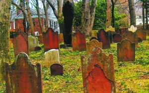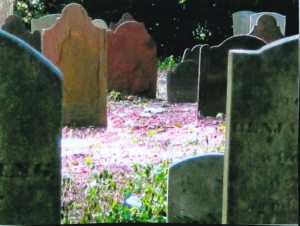
Port Washington is the site of centuries-old family burial grounds. The town was settled in the early 17th century by the Dutch and later by the English.
The Cornwall Cemetery, located on Soundview Drive in Port Washington North, was carved out of land owned by John Cornwall, the largest landowner on the peninsula, who received a land grant in 1677 from Governor Andros, the English Administrator for North America. Cornwall added to his property by purchasing more land from the indigenous people, the Matinecocks. Many local settlers resented Cornwall’s dominion over land they considered common grazing land. His house was burned down, but was later rebuilt. In 1695, Cornwall sold most of his property to John Sands. The tiny Cornwall family burial contains only eight complete headstones. A commemorative marker shows the interments date from 1676 to 1870.
John Sands and his brothers, Samuel and James, came from Block Island in 1691. John, called Captain Sands, as he was a merchant seaman, built a house in 1695 in Sands Point. He set aside land for a burial ground on the west side of Sands Point Road near Middle Neck Road. The earliest grave is that of his 10-year-old son, who died in 1704. John and his wife, Sibell, are buried side by side. Their grave markers are embellished with winged heads of cherubs. The words on one grave shows the quaint wording of those times: “Here lieth ye body of Sibell ye wife of John Sands died Decemr ye 23 d 1733 in ye 68th year of her age.” One hundred and twelve family members and friends were interred there until 1867, with 12 rows of headstones. In 1992, the Sands Family Cemetery was placed on the National Register of Historic Places.

The Monfort Cemetery, a one-acre plot of land located on a hill behind the post office parking lot, was originally part of a large farm owned by Daniel Rapelje. Early Dutch settlers, the Onderdonks, Schencks and Hegemans, bought the acre in 1786 from Rapelje as a burial place for family members. It contains 118 graves arranged by family in 13 rows. The earliest grave, that of Andries Onderdonk, dates to 1731, a half century before the purchase. It isn’t known if his remains were moved there or if he was originally buried there. The Monforts, many of whose ancestors are buried in the cemetery, owned and maintained it long after the last burial in 1892. In 1984, Burtis Monfort transferred it to the Town of North Hempstead. In 1988, it was placed on the National Register of Historic Places.
The earliest grave markers were made of sandstone with a tripartite shape. The center and tallest lobe served as a head with eyes, nose and mouth. The smaller lobes were embellished with spirals. By the end of the 18th century, the center lobe bore only an inscription such as “In Memory” or “In Memoriam.” In the 19th century, unadorned marble, which seems more weather-resistant, was common. Each showed the name of the deceased with birth and death dates.
All three of these burial grounds are interred the remains of Revolutionary War patriots. Some fought for independence from Loyalist Hempstead leading to the establishment of the Town of North Hempstead and later descendants fought in the Civil War. Our local historian Dr. George Williams wrote that old gravestones “are an important legacy of the community’s early settlement and growth. They provide information on social and religious customs of former times.”


