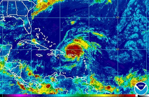
This image provided by NOAA acquired at 6:45 a.m. EDT Monday, Aug. 22, 2011 shows hurricane Irene, center right, approximately 55 miles West Northwest of San Juan Puerto Rico. According to the National Hurricane Center, Irene has maximum sustained winds of 75 MPH and is moving west northwest at 14 MPH. (AP Photo/NOAA)
This image provided by NOAA acquired at 6:45 a.m. EDT Monday, Aug. 22, 2011 shows hurricane Irene, center right, approximately 55 miles West Northwest of San Juan Puerto Rico. According to the National Hurricane Center, Irene has maximum sustained winds of 75 MPH and is moving west northwest at 14 MPH. (AP Photo/NOAA)
Hurricane Irene has already left more than one million people in Puerto Rico without power and now weather officials say it is headed towards the United States and could hit the US by this weekend.
Right now those in the southern part of the US–Florida, Georgia and South Carolina, specifically–are being warned that they could be hit by Hurricane Irene by Friday.
The Hurricane Center says a major factor in the intensity of Irene will be the hurricane’s interaction with land. If the hurricane heads over Hispaniola’s mountains, the storm could weaken. If not, Irene could end up becoming stronger over the next few days.
.
Irene, which began as a tropical storm, became an official hurricane early Monday morning while moving through Puerto Rico with heavy rains and winds.
.
As of Monday morning, Hurricane Irene was moving at about 12 miles per hour, with winds of up to 75 miles per hour. Irene is traveling west/northwest and is centered about 25 miles west of San Juan, Puerto Rico.
.
South Florida has already begun emergency preparations for the storm. The U.S. National Hurricane Center says Irene could hit the area as early as Thursday.
.
Irene is the first hurricane of the Atlantic hurricane season.